Spotlight: Geospatial Technologies
Geospatial technologies
Geospatial technologies describes a wide range of tools that contribute to the acquisition, visualization, mapping, and analysis of the Earth and human societies. Geospatial technologies have a varied and growing range of applications, and are used in everything from navigation to environmental protection to law enforcement. The U.S. Department of Labor considers geospatial technologies a high-growth industry, particularly within the public sector (federal, state, and local governments). The private sector market has been growing at about 35% a year. Geospatial technologies include:
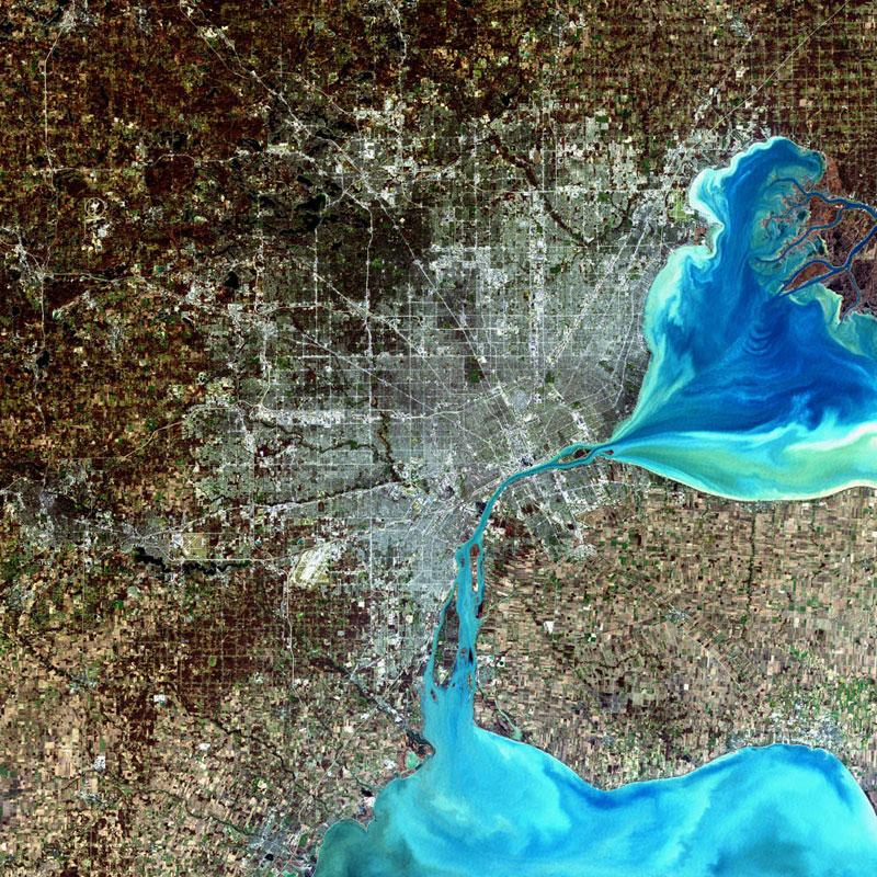
Remote Sensing: Remote sensing describes the collection of imagery and data that from space or airborne cameras. Remote sensing can be used to assess the earth’s surface and atmosphere. For example, the image on this page shows Detroit, Michigan; the image was taken by the Landsat 7 satellite’s Enhanced Thematic Mapper.
Geographic Information Systems (GIS): A suite of software tools for creating, storing, mapping, and analyzing data. GIS can be used to help understand the complex interrelationships of physical and cultural phenomena.
In short, geospatial technologies help us observe and study the Earth system and its dynamic physical and human environments.
Certificates
The Geography Department offers undergraduate students two certificate programs in this area, one in GIS and one in Geospatial Technologies. More information about each is available at the links below:
Geospatial Technologies Certificate ![]()
For more information about the certificates, including enrollment procedures, please contact the respective coordinators: Dr. John Carroll (GIS Certificate, jcarroll@fullerton.edu) and Dr. Jindong Wu (Geospatial Technologies Certificate, jindongwu@fullerton.edu).
Courses
The Geography Department offers a number of courses in remote sensing and GIS that help prepare students for careers in environmental analysis, planning, and resource management and conservation. With well-equipped teaching and research facilities, the department works to ensure that students working with geospatial technologies have access to state-of-the-art technology and equipment. The course offerings in geospatial technologies include:
GEOG 281:Mapmaking with Geographic Information Systems – principles and practices of effective map-making using GIS software.
GEOG 480*: Field Mapping: Field-based study of the principles and techniques used in constructing a digital spatial database from field observations utilizing traditional field methods, GIS and GPS technology. Prerequisite: GEOG 281.
GEOG 481*: Geographic Information Systems: Introduction – introduction to several techniques associated with GIS and computer-assisted cartography, including conversion of maps and spatial data to digital form, database mapping, analysis of spatial data, and the design and production of computer-generated maps.
Geog 485*: Geographic Information Systems: Principles and Applications – Integrated computer-assisted methods for handling spatial data, including database design, data conversion and updating, information retrieval, analysis, modeling and mapping. Prerequisite: GEOG 481 or equivalent.
GEOG 486*: Environmental Remote Sensing – fundamentals of remote sensing science and digital image processing. Prerequisite: MATH 110 or equivalent.
GEOG 488*: Land Use Analysis – spatial and temporal analysis of urban and rural land use and land cover change.
GEOG 489*: Digital Image Processing – beginning and advanced techniques in digital image processing. The science of remote sensing with a primary focus on how to process and interpret remotely sensed environmental data using image processing techniques. Prerequisite: GEOG 486.
GEOG 530T: Monitoring Ecosystem Processes – remote sensing of terrestrial ecosystem processes that influence global carbon cycle and climate change.
* Courses offered for both undergraduate and graduate students.